Aboriginal and Torres Strait Islander people believe they have lived on the Australian continent and managed its lands and waters since the beginning of time. They are not a single group, but rather they comprise hundreds of clans, each encompassing several sub-groups. Geographic features may function as territorial and linguistic boundaries, which each clan is called to strictly observe. The Gadigal (“the People of the Grasstree”), for instance, are a subgroup of the Eora Nation, and the Traditional Custodians of the land now occupied by Sydney’s central business district. In many cases, Aboriginal ancestral lands overlap with non-Indigenous state boundaries.
What Do We Mean by Eastern Australia?

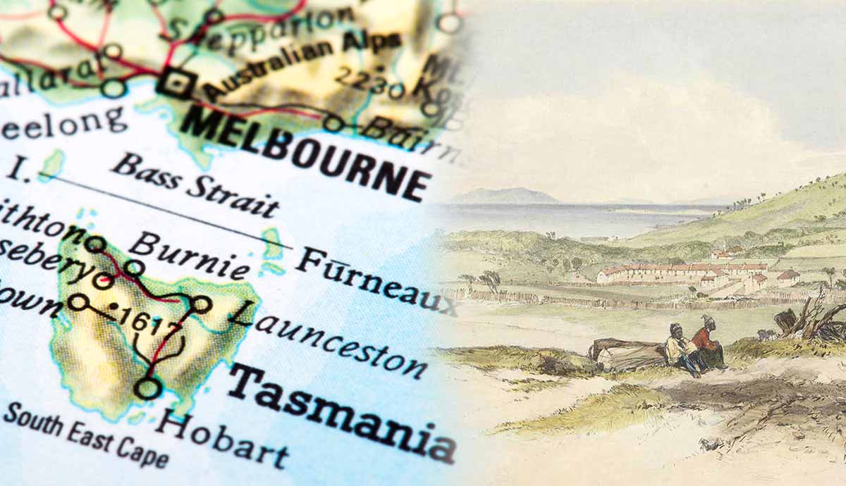
In addition to the Australian continent, the Commonwealth of Australia comprises Tasmania (known during the colonial period as Van Diemen’s Land and separated from the Australian mainland by the Bass Strait) and the 8,222 islands that punctuate the waters of the Pacific and Indian Oceans. Some are tiny and sparsely inhabited, while others are massive. Melville Island, for instance, is Australia’s second-largest island, and Kangaroo Island in South Australia is the third-largest.
The mainland states of Victoria, New South Wales, and Queensland comprise the Eastern Australia macro-region, along with Tasmania, the Australian Capital Territory, and the Jervis Bay Territory (created in 1915 as an enclave within New South Wales to give access to the sea to the Australian Capital Territory). The term “Eastern Australia” is open to interpretation. Sometimes, for instance, it only refers to mainland states (and territories), excluding Tasmania, while other times it includes South Australia too.
Australia also comprises ten territories. Three are internal, meaning, they are all located on the Australian mainland. They are the Northern Territory, the Australian Capital Territory (a landlocked enclave within New South Wales with Australia’s capital city, Canberra), and the Jervis Bay Territory.
In addition to the internal territories, Australia has seven offshore territories. They are all self-governing, but some of them, such as the Ashmore and Cartier Islands are uninhabited and among the most remote places in the world (Heard Island and McDonald Islands, for instance). Before the arrival of the British in 1788, all the land that now falls under the name of the Commonwealth of Australia, with its six states and ten territories, was inhabited by Aboriginal people. It was (and still is) Aboriginal land.
New South Wales

The European colonization of Australia began on the shores of present-day New South Wales. The first convict settlement was established on January 26, 1788, in Port Jackson, near Sydney Cove. Today, New South Wales is the state with the highest number of Aboriginal people (followed by Queensland and Western Australia) and the lowest proportion of First Nations residents among its population (while Queensland is, interestingly, the one that has the highest). In 2021, 278,000 people identified as Aboriginal in New South Wales, representing 3.4% of the population.
Sydney was established on the lands of the Eora, the Custodians of the Sydney harbor foreshores, and the strip of land between Port Jackson and Botany Bay. They still refer to Sydney as “Eora Country.” The Eora Nation comprises 29 clan groups, which are often extremely different from one another in terms of languages, songs, and body decorations.
The lands of the Eora neighbored those of the Dharug (Darug or Daruk), the Traditional Owners of the Cumberland plains region, an inland area delimited in the south by the Georges River, and in the north-west by the Hawkesbury River, which stretches west up to the Blue Mountains.
At the time of contact, the Dharug lived in semi-nomadic communities, gathering food and hunting. Some sources indicate that almost half the Dharug population died of smallpox within three months after contact. Today, the Dharug are particularly active in the revitalization of the language of their ancestors. The lands of the Dharug neighbor those of the Wiradjuri Nation, who inhabit a vast part of central New South Wales, a region of hills (in the east), grasslands, and river floodplains (in the west).

Their lands stretch from the western foothills of the Blue Mountain to Albury in the south, along three main rivers, the Lachlan (known as Gulari), the Murrumbidgee, and the Macquarie (Womboy). The Wiradjuri once used bark canoes and rafts to fish and hunt. Trees were sacred. They could be “scarred,” their bark removed to make canoes or weapons, but they were seldom cut down. On some of these trees, we can still see the oval-shaped scar left by the Wiradjuri to collect large sheets of bark.
(Aboriginal) Victoria

In Victoria, as well as in some areas in northern New South Wales and South East Queensland, Aboriginal people refer to themselves and their culture as Koori (or Koorie, according to a more recent spelling). In some cases, they identify according to their clan’s name, the specific place their group is from, or their language group. Upon contact in 1788, present-day Victoria was home to three main Aboriginal nations: the Yorta Yorta, the Gunai (or Kurnai), and the Kulin. Most of the Aboriginal languages spoken then are now extinct. Among the few that survived are the Yorta Yorta language (also known as Yotayota) and the Gunaikurnai language, spoken by the Gunai.
Yorta Yorta and Wurundjeri activist, model, and singer Dr Lois Peeler, worked for years with fellow Yorta Yorta woman, Sharon Atkinson, and Dr Heather Bowe from Monash University to ensure the survival of the language of her ancestors.
Their decade-long work resulted in the Yorta Yorta Language Heritage, a comprehensive account of the Yorta Yorta language published by Monash University. In describing her people, Lois Peeler once said: “Yorta Yorta people are River People. Our beliefs, traditions, sustenance, existence, and stories come from our ancestral river, Dungala. The Dungala, or Murray River, is sacred to Yorta Yorta Dreaming. In the Aboriginal world view, the Goulburn and Broken Rivers that feed the Murray are of immense importance.”
Today, the border between Victoria and New South Wales cuts across the ancestral lands of the Yorta Yorta Nation, which stretch across present-day southern New South Wales and north-eastern Victoria, around the junction of the Murray and Goulburn Rivers, a land of forest-wetlands, rivers, creeks, and lagoons. The border between New South Wales and Victoria runs precisely along the Murray River, with Victoria extending from the southern end of the Great Dividing Range.

The Yorta Yorta Nation has a long history of activism. William Cooper (1861-1941) was a Yorta Yorta man from Moira. In 1933 he petitioned King George V for Aboriginal representation in the Commonwealth parliament and helped organize the first Aboriginal Day of Mourning on January 26, 1938.
In 1994, the Yorta Yorta lodged their application for Native Title with the National Native Title Tribunal (NNTT). On December 12, the High Court dismissed their claim, but, to put it with Peter Seidel, “the system has failed the Yorta Yorta peoples, not the Yorta Yorta peoples the system. The Yorta Yorta struggle for justice continues, unabated, unsatiated” with a “determination born of the knowledge that this ‘always was, always will be, Yorta Yorta land.’”

The Gippsland region in southeastern Victoria has two traditional custodians, the Gunai and the Boonwurrung.
The Gunai Nation (Gunnai, Kurnai, or Gunaikurnai) comprises five major clans, scattered across the Gippsland region, from the Snowy River in the east to Warragul in the west and the southern slopes of the Victorian Alps. During the first years of colonization, the lands of the Gunai were repeatedly traversed by settlers and explorers.
The third permanent settlement in Victoria was established in 1835 by a Scottish immigrant and explorer, Samuel Anderson on the Bass River. Five years later, Polish explorer Pawel Strzelecki named the region in honor of his sponsor, George Gipps. Before contact, the five Gunai clans moved freely and regularly across Gippsland. Their diet was varied, just like the lands they inhabited. Gunai men and women would hunt kangaroos, as well as possums, emus, wombats, and koalas. They would eat ducks, frogs, goannas, pelicans, swans, mussels, and abalone. The bark of the wattle blackwood was used for bathing rheumatic joints.

When someone fell sick, the Gunai would turn to the bush, tea trees, and river mint. The Gunai shared the western border of their country with the Boonwurrung, one of the five clans of the Kulin Nation. Conflicts between the two groups continued up until the 1860s.
Melbourne was built on the lands of the Boonwurrung, the custodians of a large region extending from Wilson’s Promontory to the Werribee River and inland to the Dandenong Ranges. The coast from Westernport Bay to Anderson’s Inlet and the whole of Mornington Peninsula are also Bunurong country. This is a land shaped by water, a network of creeks, lagoons, wetlands, and hills. Unsurprisingly, the Boonwurrung call themselves “saltwater people,” with the word wurrung meaning “mouth” as well as “lips” and “language.” Before contact, they could rely on an abundance of aquatic birds, from pelicans to black swans to curlews and herons, as well as emus and kangaroos.
Queensland

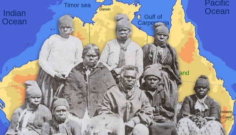
Queensland is the second-largest of the Australian states. In the 2021 Census of Population and Housing, 237,000 people identified as Aboriginal. The majority of them live in Brisbane and Moreton Bay. 9.2% identified as Torres Strait Islanders. The lands James Cook claimed for the British Crown in 1770 while mapping the coast of Queensland, were inhabited by several Aboriginal groups. Bedanug, for instance, which he renamed “Possession Island,” was a sacred place to the Gudang (Djagaraga) and the Kaurareg peoples. Present-day Brisbane was built on the ancestral lands of the Turrbal, which they call Mianjin. In the north, the lands of the Turrbal people neighbor those of the Gubbi Gubbi (also known as Kabi Kabi), one of Queensland’s Murri language groups. Murri, much like Koori, is also the name Aboriginal people from modern-day Queensland (and north-western New South Wales) tend to identify themselves with.
In addition to the Gubbi Gubbi, some of the largest groups within the Murri peoples are the Kamilaroi (whose ancestral lands extend across the border between New South Wales and southern Queensland), the Jagera (although some believe the Turrbal to be a subgroup of the Jagera since the unofficial borders of their lands largely overlap), the Jirrbal (the traditional custodians of the fertile Atherton Tableland on the upper Murray River), the Goreng Goreng (an inland group inhabiting land between the Boyne Valley and the Great Dividing Range), and the Wik (their lands stretch from the shores of the Gulf of Carpentaria to the central highlands in the interior).
The Traditional Custodians of Moreton Bay in southeastern Queensland are the Quandamooka. The group comprises three distinct tribes, the Ngugi, Nunukul, and Goenpul, who live primarily on Minjerribah (known as North Stradbroke Island) and Mulgumpin (Moreton Island).

Moreton Bay is home to many Aboriginal activists, poets, and academics, such as Oodgeroo Noonuccal, Lisa Bellear, and Aileen Moreton-Robinson. Most of these clans were and are extremely close in terms of language (they all spoke languages belonging to the Pama-Nyungan group), cultural practices, and, unfortunately, a history of colonial violence.
During the colonial period, Queensland and New South Wales were soaked in blood, mainly (although not exclusively) that of Aboriginal people. Around 40 and 50 Kamilaroi, for instance, were butchered between December 1837 and January 1838 in retaliation for the killing of five stockmen during the Waterloo Creek Massacre, also known, appropriately, as the Slaughterhouse Creek Massacre.
The Jagera people were particularly determined to resist the incursions on their lands. In September 1843, 100 Jagera men and women, led by Multuggerah, ambushed a large group of squatters and sent them on the run. Massacres and punitive raids continued well into the 20th century.
Tasmania-Lutruwita

Today they are commonly known as Aboriginal Tasmanians, but the name they have always called themselves is Palawa, “the name of the ‘first man’, who was created from the kangaroo by a creation spirit.” The ancestors of the Palawa arrived in the Tasmanianian peninsula around 40,000 years ago.
After the rising of sea levels, Tasmania was cut off from the Australian mainland and so were its inhabitants, who remained entirely isolated for about 8,000 years. Then the British came. In 1803, the Palawa population numbered between 3,000 and 15,000. The Indigenous name of Tasmania, the smallest Australian state in terms of population and land, is Lutruwita. During the colonial period, it was known as Van Diemen’s Land. Today, it’s called Tasmania, after Dutch navigator Abel Tasman (1603-1659), who landed on Tasmanian soil in 1642 (but encountered no Palawa). More than a century later, in 1777, James Cook landed on Bruny Island.
Contact with the Palawa was peaceful. By the turn of the century, sealers began establishing semi-permanent camps on the islands in the Bass Strait, trading with the Palawa and eventually establishing families with Palawa women (who were extremely skilled in seal-hunting). However, over the first twenty years of British colonization, between 1803 and 1823, relations between Aboriginal people and the foreigners soured.
Convicts and settlers would often abduct Indigenous women, while children were kidnapped for labor. Venereal diseases spread among the Palawa population, causing infertility among the women, along with tuberculosis, influenza, and pneumonia. The brutal Black War of 1828-32, and the forced resettlement of Aboriginal Tasmanians to Flinders Island, did the rest. In 1847, the Palawa who had survived the living conditions on Flinders Island were transferred to Oyster Cove. Many died during the trip.

After the death of Truganini, the last woman solely of Aboriginal Tasmanian descent, at Oyster Cove in 1876, British authorities felt entitled to pronounce Palawa officially extinct. For decades, Fanny Cochrane Smith, who died in 1905, was believed to be “mixed-race,” and thus not the “last” Aboriginal Tasmanian.
Today, most (but not all) of what we know about pre-contact Palawa culture, worldview, totems, and languages comes from what European settlers and missionaries deemed worth recording in their journals. It is believed that at the time of contact with the British, the Palawa were divided into nine Nations, further divided into clans. Hobart, the capital of Tasmania, was established in 1803 as a penal colony on the lands of the Nuenonne people, part of the South-East Nation (which is also the name of the language spoken, among others, by Truganini).

The ancestral lands of the Paredarerme, the largest Tasmanian Nation, extended around present-day Bridgewater and Herdsmans Cove, including New Norfolk, Jordan River, and the Derwent estuary. Inland were the lands of the Lairmairrener, one of the five clans of the Big River Nation, who occupied central Tasmania-Lutruwita, while the island’s western coastlines were inhabited by two major nations, the Toogee, south of Macquarie Harbour, and the Peerapper. The latter’s ancestral lands extended north of Macquarie Harbour to encompass Hunter, Robbins, and Three Hummock Islands, and then east, along the northern coastline, to present-day Wynyard.
Because of the upheaval caused by colonialism, we have very little information about Tasmanian Indigenous languages. We owe most of what we know about them (such as the linguistic structures of the languages spoken by the Pyemmairrener and the Tommeginne) to the work of historical linguist Claire Bowern.
Far from being comprehensive, this article only discusses the main Aboriginal groups from present-day Eastern Australia. The Eora Nation, for instance, is just one of the many coastal Nations inhabiting New South Wales. Equally important groups are the Yuin (south of Sydney), the Dharawhal (the University of Wollongong exists on their lands), the Worimi (around Nelson Bay), and the Awabakal (around Newcastle). Similarly, the Boonwurrung are only one of the five clans of the Kulin Nation.
For a more detailed description of Aboriginal Nations from Eastern Australia, from the Torres Strait or the Cape York Peninsula, the reader can rely on the detailed AIATSIS map of Indigenous Australia, on the important work carried out by Aboriginal Heritage Tasmania, as well as on the information provided by the official websites of the single Aboriginal Nations.