With modern GPS, we often don’t think too hard about how to navigate, but GPS does not work very well on the open sea. That is why modern ships are equipped with technology such as radar and a gyrocompass. But how did our ancestors manage to navigate the high seas and discover new lands without modern technology? Discover some of the incredible tools, from astrolabes to sextants, that ancient sailors used to navigate the world.
Astrolabes: Astronomical Maps

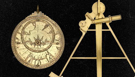
Astrolabes are sometimes described as ancient Swiss Army Knives or smartphones because they had so many applications. They are essentially handheld star charts that model the locations of the visible celestial bodies.
While that might seem simple enough, you can do a lot with that information. According to the 10th-century astronomer Abd Al-Rahman Al-Sufi, there are more than 1,000 applications for an astrolabe, from astronomy to architecture to farming and, of course, navigation.
Astrolabes were first invented in the ancient Greek world in the 3rd or 2nd century BCE and were used by astronomers. It is said that the famous astronomer Ptolemy from Roman Egypt, also used one, in the first century CE.
By the medieval era, astrolabes were adopted by Muslim astronomers. Among other things, they used astrolabes to determine precise daily timing for prayer and the direction of Mecca. But they also made changes to the device to make it more effective for navigation at sea. Muslim astrologers would go on to invent the spherical astrolabe in the early 10th century, and a geared mechanical astrolabe in the 13th century.
Component Parts of an Astrolabe

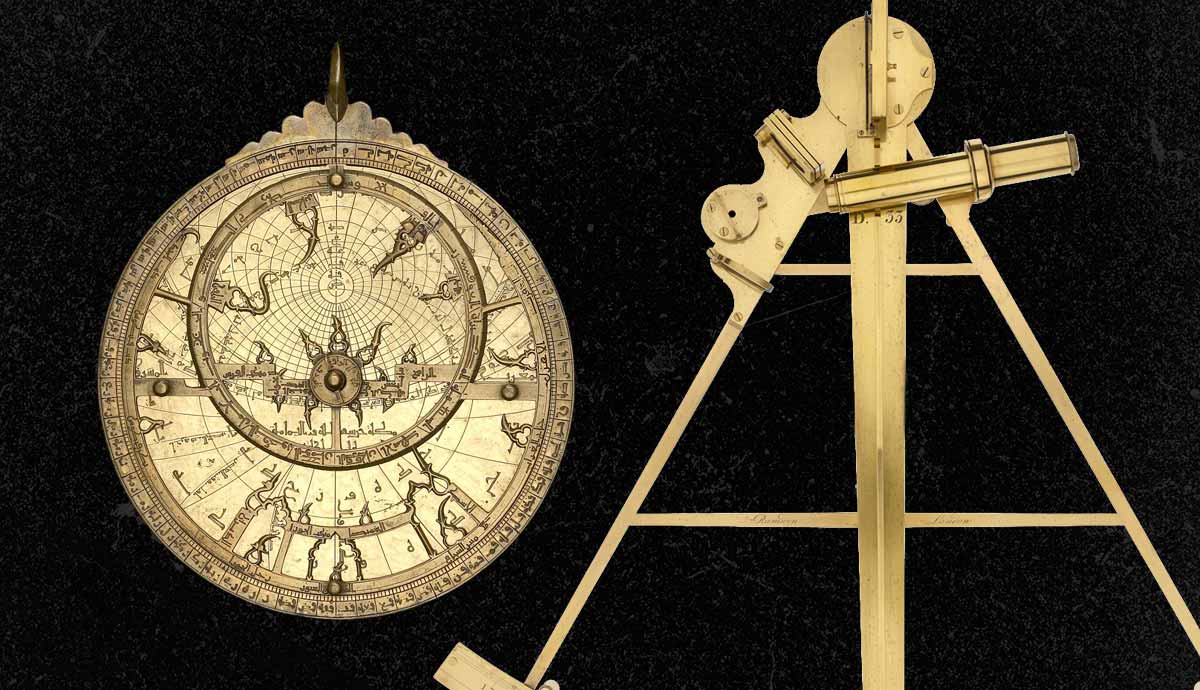
A basic astrolabe begins with the mater, which is a disc that is prepared to hold together all the elements of the device. Around the outside rim of the mater is a degree scale and scale for hours. In the center of the mater, the plate is placed, which shows a two-dimensional flat representation of a three-dimensional sphere, constructed using a mathematical technique known as stereographic projection. These models need to look different depending on latitude, so most astrolabes come with several plates that can be stacked on top of each other in the womb of the astrolabe when not in use.
On top of the plate, a rete is placed, which is a cut-out plate with star pointers to mark the relative locations of certain stars. This can be rotated on top of the plate to create a star map. The rete will also have an elliptical ring that tracks the annual path of the Sun as seen from Earth. On top of all of this is a simple rule, which is used to locate positions on the plate and rete and relate them to the scale on the rim of the mater.
On the very bottom of the astrolabe on the back of the mater is an alidade. It has small pinholes that are used as sights to measure the altitude of an object above the horizon.
Navigating With an Astrolabe

When it came to navigating at sea, the astrolabe was primarily used for determining the current latitude of the ship. This was done by measuring the altitude of the Sun at noon or a specific star at night. The degrees of the object above the horizon gave you an idea of how far north or south you were. Of course, what the measurement meant varied depending on the time of year, so the rete is used to adjust the instrument based on which zodiac sign the Sun is currently in.
While astrolabes were effective, they were also elaborate and expensive, so they were not always the preferred tool for sailors. Also popular was the Kamal, a simple Arabian navigational tool that worked on the same principle. It was a rectangular plate that a person could hold up in front of their face so that the top edge aligned with the North Star and the bottom edge with the horizon. They would then measure the distance between the plate and the tip of their nose with a string tied to the center of the plate to get the angle.
Sextants: Look to the Horizon

Sextants use a similar premise to astrolabes to navigate at sea, but sextants were designed specifically for this purpose. You use the sextant to determine the angle between the horizon and a celestial body to determine your latitude.
But the sextant, with its simpler design, means that you can only measure the angle, and cannot use the instrument to account for things like the time of year. Instead, you must measure the angle of the Sun at noon or the Polaris star in the northern hemisphere at night, then you need to consult an almanac prepared by astronomers to interpret what the angle tells you that your latitude is on that date.
How did your latitude help with navigation? You might know the latitude of your home port or your destination, or explorers may have a latitude they wanted to keep to. Therefore, knowing your latitude helped you determine whether you needed to move further north or south.
Navigators based their longitude on their speed, how long they had been traveling, and whether they had been traveling in a direct line. Again, measuring latitude was useful for this final component. This longitude calculation is called “dead reckoning” and doesn’t account for variables such as ocean currents. So, navigators needed to be good mathematicians, and could still miscalculate their location.
Before the Sextant

Until the 1400s, European sailors mainly used the position of Polaris to determine their latitude. But as the Portuguese started sailing south down the African coast and past the equator, the star was no longer visible. Instead, they had to start determining the angle of the Sun at noon.
Initially, this was done with a quadrant, which was based on an astrolabe but only measured 90 degrees. It used a hanging plumb bob to establish a vertical line of reference, but this was very difficult to use on the deck of a moving ship.
Consequently, the quadrant was then replaced by a cross-staff, which worked a lot like a Kamal, but looked more like a Christian cross that the navigator would hold up to the eye like a bow and arrow. The user moved the intersecting piece of wood up and down the long piece until one end met the horizon and the other the sun. Where the shorter piece is on the longer one gives the angle.
The problem with cross-staff was that you had to focus on both the horizon and the sun at the same time. Also, using the naked eye, it was almost impossible to see nightly bodies, like Polaris.
Invention of the Sextant

Inventors wanting to improve the instrument used the same principles but introduced mirrors and prisms to improve visibility and magnification. This eventually gave rise to the sextant, which uses two mirrors to view the heavenly body and the horizon.
To make it work, you hold the sextant vertically and point it toward the celestial body. Now sight the horizon through an unsilvered portion of the horizon mirror. Then adjust the index arm until the image of the sun or star, which has been reflected first by the index mirror and second by the silvered portion of the horizon mirror, appears to rest on the horizon. The altitude of the heavenly body can then be read from the scale on the arc of the instrument’s frame.
The instrument quickly became more complex, adding magnifying lenses and other features. These types of instruments were used by some of the world’s most famous explorers including Christopher Columbus, Vasco de Gama, Francis Drake, and Ferdinand Magellan.
Pelorus: Polynesian Compass

It was not just Arabs and Europeans that were navigating the high seas. Polynesians living on the Pacific islands regularly navigated thousands of kilometers of open sea between Hawaii, Easter Island, and New Zealand.
The Polynesians quickly became expert navigators using a variety of techniques including monitoring bird movements, wave patterns, and patterns of bioluminescence that can indicate the direction of land.
They also tracked the position of the stars. They had a star map of 150 stars that rose on the horizon at different times throughout the year. They knew the islands that each passed over and used them to navigate. When a star rose too high for navigation or sunk beneath the horizon, they would choose another star to orient themselves. The Polynesians created physical star maps to pass on this knowledge.
This kind of “star compass” navigation was the inspiration for the modern Pelorus. A Pelorus looks like a compass with a telescope attached, but it doesn’t have a way to find magnetic north. Instead, it is set towards the front of the ship, and then the relative bearings of observable bodies are noted.
The Magnetic Compass

And what of the most familiar navigation tool, the magnetic compass? This is a fairly simple instrument. It has a magnetic pointer that is drawn to the Earth’s magnetic field. It is allowed to rotate freely on top of a plate showing the cardinal directions. If you always know where north is, then you know the other directions.
Around 2,500 years ago the Greeks understood magnetism, though they don’t seem to have utilized it for navigation. Around the same time, the Chinese also understood that you could temporarily magnetize an iron bar by rubbing it against a naturally occurring magnet, called a lodestone. They created early compasses where a magnetized iron needle was attached to a piece of wood or cork and allowed to float freely in a bowl of water, pointing north.
Dry compasses started to emerge around the world from around the 12th century, in Europe, the Middle East, and China. By the 15th century, explorers realized that magnetic north and true north were not the same. While this is barely noticeable at the equator, it becomes increasingly noticeable the closer you get to the poles. They created error correction tables to compensate.
Despite the initiation of the global positioning system by the US Defense Department in 1973, magnetic compasses are still a very common navigational tool found on most boats and airplanes.
For the curious, you do tend to get compasses designed to work in either the northern hemisphere or the southern hemisphere, though you can also get global compasses. This doesn’t mean that your single-hemisphere compass will stop working the moment you cross the equator, but it could become less accurate.
