Cartography, the art and science of representing the Earth on maps, has been central to the understanding and exploration of the world since ancient times. The great cartographers, such as Claudius Ptolemy, Martin Waldseemüller, Muhammad al-Idrisi, Abraham Ortelius, and Gerardus Mercator, have left an enduring legacy in history.
Their ability to collect, synthesize, and represent geographical information has transcended the ages, influencing the expansion of geographical knowledge, navigation, and exploration. Through their cartographic innovations, these figures have shaped our perception of the world and laid the foundations for modern cartography.
1. Claudius Ptolemy

Claudius Ptolemy, more commonly known just as Ptolemy, was a Greek cartographer born at the beginning of the Common Era, either in the first or second century. Besides being one of the first major cartographers in Western history, Ptolemy was also an astronomer, a chemist, and a mathematician. A well-rounded man of science, Ptolemy likely worked in the equally astonishing Library of Alexandria. He is believed to have been a Roman citizen living in Egypt when it was a territory under the Roman Empire.
Ptolemy is known for his major treatises on science, ranging from major consequential works in astronomy, like the Almagest, his most famous piece, to works in astrology, like his Tetrabiblos. Ptolemy’s other major treatise is the Geography, arguably the first major Western cartographical compilation. Alongside his Geography, Ptolemy’s maps and geographical descriptions were used by many other cartographers and navigators, helping redefine and reshape the perception of the known world. His work facilitated exploration, allowing ancient cultures to trade and expand beyond their borders. Even so, his Geography remained relevant well into the Modern Age.
Above all, Ptolemy is recognized even today not just for his contributions to cartography but for the development of the sciences in Antiquity. Ptolemy’s work was monumental, being replicated and expanded upon by both Western and Eastern cultures and epicenters of science. His Geography was arguably the most detailed and precise representation of the known world at the time. Even with the limitations of his time, Ptolemy’s cartographical work was accurate and greatly consequential.
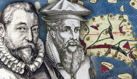
2. Muhammad al-Idrisi

An oft-forgotten figure in the West, Muhammed al-Idrisi was a massively influential and consequential cartographer from the Middle East and the Arab world. His most renowned work, the Tabula Rogeriana, is an atlas commissioned by the Norman King Roger II.
Al-Idrisi had been invited and welcomed into the Norman King’s court to aid Roger II in his political and cultural agenda. Al-Idrisi appreciated the region of Sicily, Roger II’s territory, so he willingly joined the court. Al-Idrisi shared his experiences traveling throughout Europe and North Africa, a welcomed notion by Roger II, who quickly commissioned him to chart the territories.
One of the main reasons al-Idrisi is considered a great cartographer is the breadth and accuracy of his geographical knowledge. In his work, he compiled information from a variety of sources, including classical Greek and Arabic texts, as well as accounts by contemporary travelers and explorers. This meticulous approach enabled him to produce detailed maps and geographical descriptions covering vast regions of the known world at the time, from Europe and Africa to Asia and beyond. Rather than simply copying earlier maps, as was common in his day, al-Idrisi combined information from a variety of sources to create his own cartographic representations.
Al-Idrisi’s influence was lasting. His maps and geographical texts were widely known and used in medieval Europe, influencing later cartographers and contributing to the advancement of geographical knowledge in the Middle Ages and the Renaissance.
3. Abraham Ortelius

Abraham Ortelius, a 16th-century Flemish cartographer, is recognized as one of the greatest in his field because of his significant contributions to the development of modern cartography. Ortelius was also a geographer and cosmographer. His most significant work, the Theatrum Orbis Terrarum or “Theatre of the World,” first published in 1570, is considered the first modern atlas and a milestone in the history of cartography. Rather than merely collecting existing maps, Ortelius compiled a collection of high-quality maps, harmonizing and organizing them thematically to provide a coherent and comprehensive view of the known world in his time. This innovative presentation made the Theatrum Orbis Terrarum an invaluable tool for navigators, explorers, traders, and scholars of the time.
Ortelius traveled extensively in Europe and consulted a wide range of sources to ensure his maps were as accurate as possible. His career began initially as a map engraver in 1547 at the Antwerp Guild of Saint Luke. He became a trader of books and maps. His travels led him to meet another influential Flemish cartographer, Gerardus Mercator. By 1570, Ortelius had already become a published cartographer. His Theatrum Orbis Terrarum is often considered the beginning of the Golden Age of Netherlandish cartography.
Abraham Ortelius is recognized as a great cartographer because of his atlas, his commitment to cartographic accuracy and quality, and his lasting influence on the development of modern cartography. His Theatrum Orbis Terrarum remains a masterpiece of cartography and a milestone in the history of geographical knowledge.
4. Martin Waldsemüller

Martin Waldsemüller was a German Renaissance cartographer who stood out mainly for his world map of 1507, the Universalis Cosmographia, in which the New World was named “America” for the first time. An outstanding cartographer, Waldsemüller was an innovator, welcoming new information into the field of cartography. The New World was still known by many names, often very different from language to language.
The popularization of the term “America” came only after Waldsemüller’s work began to be replicated throughout Europe. The original projection was a monumental work alone. The map combined the information available at the time alongside Waldsemüllers’s own research, namely his readings of European explorers’ experiences in the New World, such as the ones of Amerigo Vespucci. The map contained some common errors of the time, with many regions of the world being distorted or just outright exaggerated. Yet the detail provided by Waldsemüller was unmatched at the time, making it a natural reference for further works of other cartographers.
Although the Universalis Cosmographia was Waldsemüller’s greatest work, his production was not limited to that map alone. After 1507, Waldsemüller worked with his main collaborator, Martin Ringmann, to create a new edition of the monumental Geography by Ptolemy. Waldsemüller produced a broad range of maps and projections that carefully reflect his ability to collect, add, and represent geographic information in a precise yet attractive manner. Beyond just contributing to the naming of the New World continent, his work was highly influential in the development of cartography as a consequential scientific and artistic discipline.
5. Gerardus Mercator

Gerardus Mercator is perhaps well-known for all the wrong reasons. His last name evokes the infamous Mercator projection, which depicts the world in a distorted way. The projection has been criticized for putting Europe at the center of the world and favoring the northern hemisphere by making countries there appear bigger than they are in reality.
While the criticisms for this type of projection are valid, Mercator’s initial intention was to create a projection that allowed for better sea navigation. In this, Mercator succeeded; his projection was widely used for its ease of use. Yet the projection stayed in the mainstream even after the need for such an analog way of navigation became outdated.
Putting aside Mercator’s infamous contribution to the world of maps and cartography, he was a highly skilled and successful professional. A mathematician, geographer, and cartographer, Mercator enjoyed constant work in his native Flanders. He was a proficient cartographer, producing dozens of maps, but he also created many other works, such as numerous publications on a broad range of subjects.
Mercator even produced terrestrial globes. Mercator was an innovator, adopting a new style for the display of information in cartography. Instead of using the bulky gothic types, Mercator used cursive to allow for more information to appear on his maps.
Mercator motivated Abraham Ortelius to make his atlas. He would later make an atlas of his own, both based on Ptolemy’s original knowledge and work. Mercator did not finish his atlas, as he died before completing it. His son, Rumold Mercator, went on to complete it instead.