The so-called Plateau is one of the six cultural areas that make up present-day Canada, the others being the Arctic and the Subarctic, the Northwest Coast, the Plains, and the Eastern Woodlands. These areas are not restricted to the border with the United States, and First Nations communities today often find themselves split between these two colonial identities. The first people to reach the Plateau did so some 8400 years ago. Their descendants, the Interior Salish, the Ktunaxa, the Chilcotin people, and the Athapaskans are the key players in the history of this vast and diverse region.
What Do We Mean by Canadian Plateau?

In North America, the territory between the Rocky Mountains to the east and the Coastal Range (also known as the Coast Mountains) to the west is called the Plateau. It coincides with the Canada-U.S. border to the south and with the Fraser River at 54° latitude to the north (although the northern border is not as clearly defined as the southern border). Fraser Canyon separates the Plateau from the Northwest Coast.
The environment of the Plateau is very diverse. The eastern Plateau, for instance, is dominated by mountains and forests, while the west is a vast expanse of sagebrush. In pre-contact Canada, the Fraser and Thompson Rivers abounded with salmon, and people tended to gather at the mouths of these rivers or along their shores. Archaeological evidence tells us that the first people to roam the Plateau came from the south about 8400 years ago.

These people hunted deer, elk, and of course, bison, for survival, as testified by microblades, chipped-stone tools, and fluted points found at several sites across the Plateau. Historians call this the Mobile Period.
The beginning of the so-called Sedentary Period, around 4,000 years ago, was marked by the establishment of large pit-house villages. By this time, the people who inhabited the Plateau had adopted a more sedentary lifestyle. Houses were traditionally built on a depression of about one meter (3.2 feet), with the circumference of the pit ranging from 7.5 to a maximum of 12 meters in diameter (24 to 39 feet). The bottom of the depression was usually occupied by a cache pit for storing dried salmon for the winter months. While the lower part of the outward-sloping side walls was made from the soil itself, the roof was made of log structures covered with waterproof bark, soil, and then sod.

In spring, grass would grow on the roof, insulating and camouflaging the semi-subterranean dwelling against the surrounding landscape. According to scholars McMillan & Yellowhorn, in winter pit-houses “probably would have resembled large mounds of snow, until one noticed well-worn trails leading to the notched-log ladders and smoke escaping from the entranceways on top.”
To date, the largest pit-house village that has been found is at Keatley Creek, near the Fraser River: the village had over 120 houses, home to something between 500 to 1000 people. Pit-houses, however, were not the only types of dwellings used by the people of the Plateau and Plains: cone-shaped tipis (also spelled teepees) and the so-called tule-mat lodge could also be seen throughout the Plateau. Just like the Great Lakes area or the Pacific Northwest, the Plateau is a border region, and its history was shaped by the establishment of the Canadian-American border.

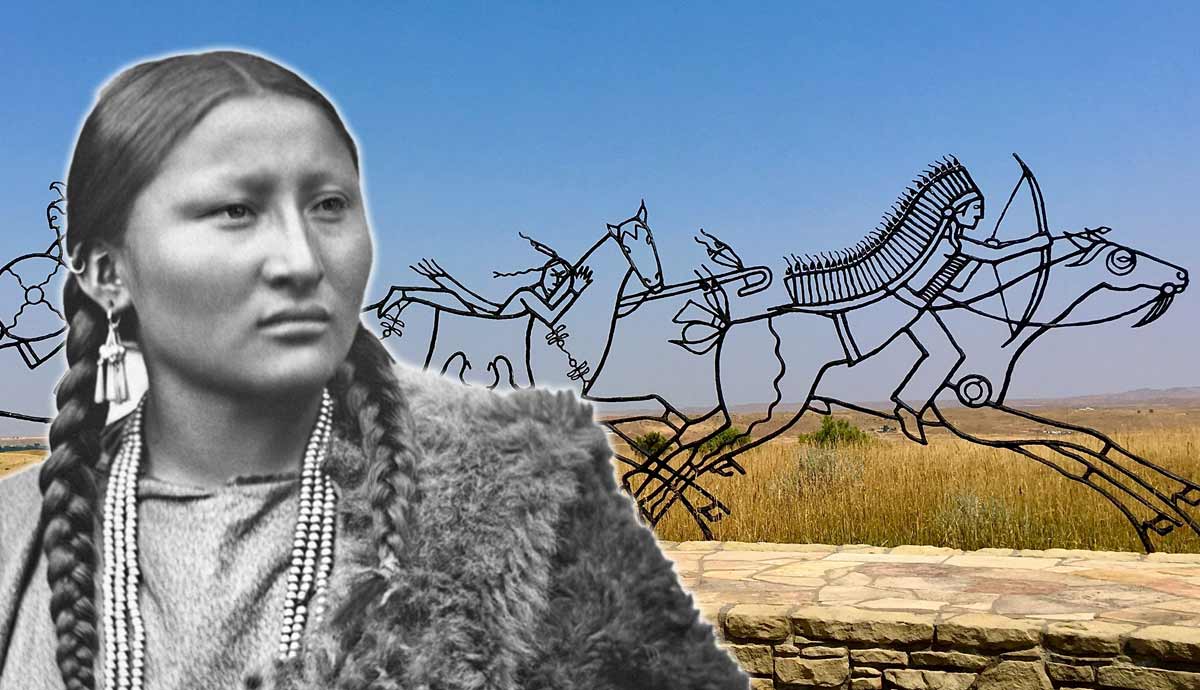
The Indigenous peoples of the Plateau were influenced, in both lifestyle and artwork, by their neighbors from the eastern Plains (from whom they adopted feather headdresses and horses), and by the Northwest Coast people (from whom they embraced specific social ceremonies as well as handles, pipes, and bowls enriched with carved images and geometric designs).
Some historians go as far as to suggest that in ancient times there was no clear-cut distinction between the cultures of the Plateau and those of the Northwest Coast. Indeed, relations between different Indigenous groups were constantly strengthened through trade, which took place mainly on the Fraser River, the longest in British Columbia. Dried salmon and imported goods, such as copper, obsidian, shell ornaments, and even turquoise, then traveled along trade routes from the coast to the interior.
The Interior Salish

The lands of the Interior Salish peoples are today split between the Canadian-U.S. border. The Okanagan Valley, located in the southernmost part of the Canadian Plateau, is the ancestral land of the Okanagans, whose territory extends across the border into Washington state.
The Okanagans often trespassed beyond the Rocky Mountains onto the Plains to hunt bison, a testament to the fact that these cultural regions did not and could never have fixed boundaries. The northernmost area of the Plateau is inhabited by the Secwepemc (also known as the Shuswap, an Anglicization of their Indigenous name). Their ancestral lands stretch from the Rocky Mountains in the east to the Fraser River in the west, including Shuswap Lake and Thompson River. The Nlaka’pamux (known for centuries by the Western name “Thompson”) occupied the Fraser Canyon region and the lower reaches of the Thompson River.

The westernmost part of the Plateau is the land of the Lil’wat (also known as Lower Lillooet or Mt. Currie Lillooet), the ancestral inhabitants of Pemberton Valley. The Stl’atl’imx (or Upper Lillooet) were stationed on the Fraser River. The Lil’wat and Stl’atl’imx were both active intermediaries in trade with various coastal groups.
The ancestral lands of the Interior Salish are known to be rich in rock art sites. Supernatural creatures appear alongside human beings and animals, all painted in red ochre. Nonetheless, these are more than just simple pictographs, as they were closely related to dreams, which the Salish people thought of as coded messages from supernatural beings.
Both men and women could become shamans in Salish society. At puberty, they would undertake solitary journeys and vigils away from the villages, often praying and fasting and waiting for the moment when they would finally be able to contact the supernatural beings hidden in the land.

Anthropologists have called these journeys “vision quests,” but many First Nations prefer to call them “dream fasts” and “dream visions.” They were widespread not only among the Plateau people but also among the Inuit and the Anishinaabe in present-day Canada and among the Siksika and Cree in the United States.
Most of the information we know about the Interior Salish peoples comes from explorer and fur trader Simon Fraser (1776-1862), who met some of them in 1808, when he descended what would later be called the Fraser River, and from anthropologist and photographer James Teit (1864-1922), who was also a tireless translator and activist. Teit writes, for instance, that the Nlaka’pamux were famous warriors who poisoned their arrow points with rattlesnake venom. Fraser relates that in 1808 the Stl’atl’imx had built fortifications around their villages during a time of war.

Just as many Northwest Coast peoples placed carved images of their dead atop totem poles (although hidden from public view), and the Nlaka’pamux and the Stl’atl’imx are said to have carved portraits of their dead.
The diet of the Interior Salish peoples depended mainly on salmon, which they fished, harpooned, speared, and scooped out of the water with large nets along the Fraser River and around Fraser Canyon. Women were responsible for cutting it, roasting it, and letting it dry on drying racks. Since dried salmon was a staple element of their diet in winter, their task was no less important than that of the men who caught it. Berries were also gathered and made into dried cakes to be stored for the coldest winter months. Other important fish included white sturgeon and trout, but salmon remained the most important. Dentalium shells were often used to embellish clothing for both males and females and were inserted as ornaments in holes drilled in the nasal septum.
The Ktunaxa

The mountainous south-east of British Columbia is the ancestral land of the Ktunaxa (also known as Kootenay or Kutenai), who call their territory (covering about 70,000 square km or 27,000 square miles) Qat’muk. Their culture has developed around the Kootenay River in southeastern British Columbia, but several Ktunaxa villages are also found in and around Arrow Lakes and the Columbia River, in western Alberta, as well as in the U.S. states of Washington, northwestern Montana, and northern Idaho.
The Ktunaxa language, today endangered, is a language isolate, with no known relationship with any other Indigenous language. Their origins are equally obscure. What we do know with greater certainty is that the Ktunaxa culture was influenced by the Plains First Nations and that, unlike other Plateau peoples, they were never sedentary, they didn’t live in pit-houses and rarely decorated their clothing.

From the cultures of the Plains they borrowed the Sun Dance ceremony, the custom of storing dried bison meat into rawhide bags called parfleches, and that of killing bison from horseback. They were also famous warriors who used to take the scalps of their defeated enemies and, although there was no class system, status depended largely on an individual’s success in battle.
The Ktunaxa were also similar to the Plains culture in their religious beliefs, with young men and women embarking on the aforementioned “vision quests” or “dream visions,” as many First Nations prefer to call them. This is certainly true for the Upper Ktunaxa, who lived closer to the Kootenay River drainage and often ventured beyond the mountains and onto the Plains to hunt bison. The Lower Ktunaxa, on the contrary, adopted fewer characteristics of the Plains. Their territory was further from the Plains, along Kootenay Lake, and they relied more heavily on deer, duck, and plant foods (such as the Interior Salish) to survive.
Anglo-Canadian explorer and cartographer David Thompson (1770-1857) passed through Ktunaxa country in 1807 and arrived in the Lakes region in 1811. Described by some as a man in between worlds, during his lifetime Thompson came to master various Indigenous languages and married a Métis woman, Charlotte Small. They remained together for 58 years.
In 1807 the first trading post was built on Ktunaxa territory, near present-day Invermere. It was not the Europeans, however, who introduced Plateau peoples to horses, but rather their neighbors from the Plains. When the first explorers crossed the Plateau, they saw some groups weakened and decimated by smallpox. Everything changed for the Plateau peoples and for the Ktunaxa in 1858, when British Columbia was declared a Crown colony.

In the same year, thousands of miners arrived in the Fraser River area in search of gold. Miners and settlers, unlike fur traders, considered Indigenous peoples a hindrance to their business and proceeded to displace them from their ancestral territories. The first reserves on the Plateau were established during the 1870s and 1880s. Tensions developed throughout the 1850s and 1860s, culminating in the so-called “Chilcotin War,” which brings us to the other major group of the First Nations of the Plateau, the Chilcotin people.
The Chilcotin or “Dentalium People”

James Teit relates that the Interior Salish peoples often called the Chilcotin “dentalium people.” In the language of the Chilcotin (or Tsilhqot’in) it means “people of the red river.” Their ancestral lands are located, in fact, around the Chilcotin River drainage between the Fraser River and the Coast Mountains in west-central British Columbia. They call their country Tŝinlhqotʼin Nen.
In the summer months groups of Chilcotin could be seen gathered along the Chilcotin River to intercept the salmon runs. The origins of the Chilcotin are rather obscure. Some believe that they moved into the Plateau region from the north not long ago, at the time of the fur trade, and that they were a so-called “late arrival.” What we do know is that Chilcotin culture is largely influenced by their northern, eastern, and western neighbors.

We know that the Chilcotin took elements from the Interior Salish peoples (such as the habit of embellishing their clothes, ears, and nose with dentalium shells), from their northern Subarctic neighbors (winter houses made of poles and logs and covered in bark), and from other Plateau cultures (some of them adopted the Plateau-style pit-house, in addition to a diet comprised of game, fish and berries). We also know that they were famous warriors, often at war with the Interior Salish Secwepemc, and that they were the ones who most strongly opposed the Western invasion of their lands.
In 1858, British Columbia was formally proclaimed a British colony. As increasing numbers of settlers and miners poured into the Plateau, Indigenous peoples were decimated by epidemics of smallpox (in 1855 and 1862-1863), whooping cough (1854), measles (five years later, in 1850), and finally the Spanish flu epidemic of 1919, in the aftermath of World War One.

Chilcotin communities were hugely affected by the construction of railways and infrastructure on their territory during the Fraser River Gold Rush and the Cariboo Gold Rush. In 1861, British aristocrat Alfred Waddington decided it was time to build a wagon road from Bute Inlet to Fort Alexandria to facilitate the movement of people to the goldfield. The road was supposed to cut across the Tŝinlhqotʼin Nen. Its construction angered the Chilcotins who, already decimated by the Pacific Northwest smallpox epidemic of 1862, feared that construction workers would carry the virus with them. And so they did.
In 1864, when a roadbuilder threatened to voluntarily bring smallpox back to the Chilcotin communities, eight Chilcotin men attacked one of the work camps, killing 14 of the 17 men stationed there. They were led by Chief Klatsassin. This was the beginning of the so-called “Chilcotin War,” also known as the Bute Inlet Massacre.

Eventually, six Chilcotin leaders were arrested and tried. Five of them were hanged, in what is now a day of mourning for the Chilcotin Nation. The sixth, Chief Ahan, was executed one year later. Indigenous people traveled on foot from as far as Bella Coola to witness the execution of their leaders. On November 2, 2018, Prime Minister Justin Trudeau visited the land of the Chilcotin people and publicly apologized for the treatment of Chilcotin chiefs in 1864 and 1865.
Four years earlier, on March 25, 2018, the British Columbia government had finally officially exonerated the “Chilcotin Chiefs” before the current leaders of the Chilcotin Nation. Some view Trudeau’s apology as the true end of the Chilcotin War, more than a century after it began on April 29, 1864, with the killing of ferryman Timothy Smith.

Another important Indigenous group living in the Canadian Plateau are the so-called Plateau Athapaskans, whose ancestral lands lie in the Subarctic. Some archaeologists believe that this group of Athapaskans migrated south from their Subarctic homelands, settling in the river valleys of south-central British Columbia. Others believe, however, that they originated from a Chilcotin war party that had gradually been absorbed by the Interior Salish. Still, archaeologists have been unable to properly date or locate Athapaskan migrations in the Plateau region.
The presence of some Athapaskans groups in the northern Plateau is the most vivid testimony to how malleable boundaries between various Indigenous groups were (and still are), and how alien the establishment of the Canada-U.S. border has always been for the First Nations of present-day Canada and the United States.