The relative security provided by the abundance of timber, salmon, and game on the Northwest Coast of present-day Canada has meant that First Nations people there haven’t had to focus on narrow survival, as the Inuit do in the Arctic. They have historically devoted some of their energies to decorative arts, performance, music, carving, and storytelling. Carved and painted totem poles were placed around houses and along shores. Colorful and elaborate transformation masks were carved for use in dramatic performances on both sacred and secular occasions. Archaeological evidence suggests that the first people to settle on the Northwest Coast did so about 14,000 years ago, at the end of the last Ice Age. Let’s look at their history and that of their descendants.
A Brief History of the Canadian Northwest Coast

The Northwest Coast is one of the six cultural areas that make up present-day Canada. The others are the Arctic and Subarctic to the north, the Plateau and the Plains (which together occupy a large central area north of the U.S. border), and the Eastern Woodlands, extending from the Maritime provinces to the Great Lakes. The Northwest Coast follows the North American coast from the Washington state border in the United States up to Alaska, including inland areas around British Columbia’s three main rivers: Fraser, Nass, and Skeena. Abundant in salmon, they were a major source of sustenance for the inland populations of the Northwest Coast. The coast is a rugged landscape of bays, fiords, and island archipelagos, with the sea as the other main source of food.

In the waters of the Pacific Ocean, the Haida, Tsimshian, Heiltsuk, Kwakwaka’wakw, and Nuu-chah-nulth people hunted seals, sea lions, whales, and porpoises, and gathered mussels and clams. While a small group of people could quickly deplete a large supply of clams and mussels, usually collected by women, salmon could support larger groups. Easy to catch, predictable, and plentiful, if properly dried it could be stored and preserved easily for the winter months.
Today, the layers of crushed mussel and clam shells accumulated by Indigenous people in their villages thousands of years ago represent one of the most important sources of knowledge about their lifestyle and culture. Similarly, the remains of sea lions, seals, and whale bones found in various burial sites bear witness to the importance of the sea, whaling, and fishing in the lives of the early inhabitants of the Northwest Coast.
“Think Hotel California for fish—they can easily check in, but they can never leave.” This is how Brian Payton describes the huge and highly complex fish trap system found in Comox Harbour on Vancouver Island, on the ancestral lands of the K’ómoks First Nation. Archaeologist Nancy Greene and her team have found the remains of more than 300 fish traps, which make it the largest such system so far discovered in North America.

Historians and archaeologists have divided the history of this region into different periods. The land first changed into the shape we know today during the so-called Emergent Period, from about 5,500 to 1,500 years ago. Sea levels began to stabilize, flooding large portions of previously inhabited areas, while vast expanses of lush cedar, fir, and spruce trees began to cover the land.

It was during this period that the Indigenous cultures of the Northwest Coast began to take on the distinctive cultural traits that the first European explorers would encounter in the early 16th century. In this regard, the whaling village of Ozette, buried for at least 300 years by a mudslide, has given archaeologists a unique insight into the culture of the Makah people, the traditional inhabitants of Neah Bay in the Washington area.
The years from 11000 to 5500 BCE are called the Early Holocene. From about 2,500 to 1,500 years ago, Northwest cultures became more sophisticated and refined. Today, they are among the most complex cultures among today’s Canadian First Nations. Increased cultural complexity led to increased warfare, as evidenced by various defensive sites discovered along the coast, and weapons found at several burial sites. Archaeologists and anthropologists believe they belonged to warrior chiefs.

To quote McMillan & Yellowhorn, “Where only eroding shell middens are visible today, villages of large wooden houses once stood. We can imagine these villages bustling with activity, the beaches in front lined with canoes and filled with the comings and goings of fishers and travellers and the welcoming of traders or guests for feasts” (198). These words seem to evoke the famous 1878 picture of the Haida village of Skidegate, with its shores lined with totem poles and canoes, in the Haida Gwaii archipelago in present-day British Columbia.
Haida Gwaii, or Queen Charlotte Islands

The history, art, and oral stories of the Haida are inseparable from their homeland, Haida Gwaii, an archipelago of red cedar-covered islands and islets off the northern coast of British Columbia. Known as the Queen Charlotte Islands from 1787 until the 2000s, in 2010 the Haida Gwaii Reconciliation Act formally stipulated that maps should be updated with the islands’ new name, Haida Gwaii. It also formally recognized the Haida Nation’s right to self-government. In English, Haida Gwaii translates as “islands of the people.” Reconciliation, in Canada as in Australia, comes through names.
Haida Gwaii consists of two major islands: Moresby Island (Gwaay Haanas) to the south and Graham Island (Kiis Gwaay) to the north. Surrounding them is an expanse of around 400 smaller islands. Archaeologists claim that the Haida people first made Haida Gwaii their home as early as 13,000 years ago.

The first Europeans encountered by the Haida were neither British nor French, but Spanish. Juan Pérez is believed to have been the first European to meet them in 1774. Four years later, James Cook (1728-1779) also sighted them. By then, the Haida Gwaii had already been introduced to the Western world as “Queen Charlotte Islands.” Less than a century later, they were officially declared a British colony.
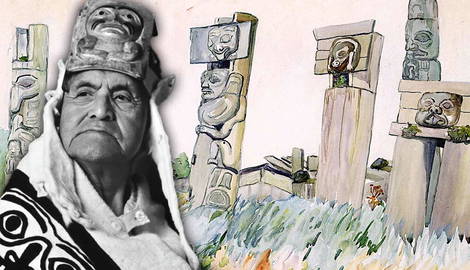
Today, Haida artwork is among the most sophisticated in the world. Pre-contact Haida were master carvers. Their works ranged from tiny carved miniatures, stylized figures, and animals on spoon handles to the huge totem poles and sculptures adorning the exterior of their houses. Interestingly, houses belonging to high-ranking people were often named.
Haida totem poles are featured in many of Emily Carr’s paintings. Dating back to the early decades of the 20th century, Carr’s works are an invaluable source of visual knowledge about the Haida people, albeit from a Western non-Indigenous perspective.

The Haida also honored the tradition of carving statues of their dead, which were then placed atop totem poles but hidden behind elegantly carved wooden boards to prevent outsiders from seeing them. In addition to being used in warfare against other Indigenous groups, the large Haida canoes were often traded for eulachon oil, transported from the interior regions along the “grease trail.”
The Haida were not only master carvers, but also feared warriors. Their warriors went into battle protected by the very material so important to their lives: cedar. Their wooden armor, visors, and helmets were carved, both to frighten the enemy and to remind them of their greatness and carving skills. Over the course of the 20th century, Haida groups, decimated by epidemics, fled to what would become the two main Haida villages, Skidegate, in the south-east part of Graham Island and Old Massett in the north. Their cedar houses and their colorful still-standing poles were left to rot and decay.
Today, the restoration of the Haida (and Tsimshian) totem poles is the most vivid testimony to Canada’s and British Columbia’s determination to acknowledge and honor the first inhabitants of these lands.

In September 1900, John Reed Swanton (1873-1958), a young Harvard-educated linguist, landed on the shores of Haida Gwaii with his young, bilingual assistant and guide, also known by his Western name Henry Moody (1871-1945). Here they listened to and noted the oral histories of the Haida as told by the blind poet, Ghandl of the Qayahl Llaanas of Qaysun (Walter McGregor). In the early 1980s, Canadian poet, translator, and linguist Robert Bringhurst set out to learn the Haida language. Once he had mastered the language, he began translating into English the Haida songs, stories, and mythic cycles Swanton had collected more than eight decades earlier.

In 2016, Margaret Atwood championed Bringhurst’s masterful translation work with London-based publisher the Folio Society and succeeded in getting it published in the United Kingdom. Without Bringhurst’s translation work, Haida’s enormous corpus of oral literature would still be largely unknown to non-Indigenous peoples. Similarly, without the combined efforts of Ghandl, Swanton, and Henry Moody, it would probably have been lost forever.
When Swanton visited the archipelago in 1900, in fact, the Haida population was already in decline. While the pre-contact Haida thrived on Haida Gwaii, the archipelago of southeastern Alaska was inhabited by the Tlingit, the second-largest northern group to inhabit the Pacific Northwest since. Several inland Tlingit communities, however, can be found in northwestern British Columbia and the Yukon. Pre-contact Tlingit were indeed great traders and their business often took them inland, where some of them mingled with the Athapaskans (or Athabaskan).

The third major northern group inhabiting the northern mainland of British Columbia, are the Tsimshian. Their traditional homeland is a land of rivers, rich in salmon and eulachon. Hence their name, which in English translates as “inside the Skeena River.” Unlike the Haida and Tlingit, the Tsimshian divided their society into four groups (or moieties) instead of two.
Like many groups from the western Canadian Subarctic, they followed a matrilineal system: all children took their mother’s kinship group. Marriage within the same group was considered incestuous. It is worth remembering that despite the physical proximity of their homelands, the Haida, Tlingit, and Tsimshian speak three unrelated languages. The Haida language is now endangered.
The Coast Salish Peoples

The Coast Salish peoples include several Indigenous groups who have lived along the Northwest Pacific Coast in British Columbia since time immemorial. Their homelands, like those of the Anishinaabeg in eastern Canada, extend across the Canada-U.S. border and include most of southern Vancouver Island and the Lower Mainland, as well as the Fraser Valley. In the United States, their territories encompass present-day northwestern Oregon and western Washington, including the Olympic Peninsula and Puget Sound, with its intricate system of canals, waterways, and basins that make up the so-called Salish Sea.
Metropolises such as Vancouver and Victoria (as well as Seattle in the United States) were all built on traditional Salish lands. We can distinguish two different groups based on the location of their ancestral lands. The Central Coast Salish, who traditionally occupied southeast Vancouver Island and the lands around the Lower Fraser Valley, and the Interior Salish, who lived (and some still do) in the interior of British Columbia.

The Northern Coast Salish (or Northern Straits Salish) occupied east-central Vancouver Island and the northern half of the Strait of Georgia, between Vancouver Island and the southwest coast of British Columbia. The K’ómoks First Nation, whose elaborate fish trap system was found in Comox Harbour by archaeologist Nancy Green, belong to the Northern Coast Salish group.
The Salish social system was more flexible than that of the other First Nations of the Canadian Northwest, and slaves were not as common. Unlike the Haida, who decorated their households with free-standing totem posts, Salish peoples tended to produce smaller but equally powerful artworks, such as baskets of split cedar root or woven cedar-bark blankets. They also used to adorn their villages with carved house posts.
The Wakashan

Since time immemorial, the Nuu-chah-nulth have occupied the west coast of Vancouver Island and the tip of the Olympic Peninsula across the border. For centuries, this tribe of famous canoe builders and sailors were known by the name James Cook adopted for them, “Nootka.” Today their descendants reject this name.
Kwakwaka’wakw is the collective name chosen by the various groups that speak the Kwakwala language and occupy northern Vancouver and Island and the nearby mainland coast. The Western world has known them by the name of “Kwakiutl” for centuries.
The Nuxalk were once known as “Bella Coola,” named after their ancestral lands around the Bella Coola Valley (and the valleys around Dean Rivers). These are just a few of the groups that make up the Wakashans.

The term Wakashan, first employed by James Cook in 1778, refers primarily to the family of Indigenous languages spoken on and around Vancouver Island and on the Olympic Peninsula in the state of Washington. It also refers to the people who spoke such languages. The diaries and letters of 18th-century explorers give us insight into the lifestyle of the Wakashans before contact.
We know that a staple of their diet was halibut and that they would paddle far out to sea to catch it. We know that their houses were made of planks, which covered both walls and roofs and could be easily disassembled. This allowed people to move more easily when they wanted or needed to. Especially in the mild season they would temporarily leave their winter homes and move to fishing grounds at the mouths of rivers.

Wakashan artists often added wings to their sculptures and hair to their masks and wolf costumes. The latter were used especially by the Nuu-chah-nulth during their winter rituals. Like the Dreamtime stories among Aboriginal Australians, dances were hereditary: they were passed on from one generation to another, often within the same families. Some of these performances, like contemporary theatre or film, were full of tricks meant to create fear and surprise among the audience. Bursting blisters full of blood were used alongside hidden strings that would make beaks open and close.
Carved masks and other regalia were used during potlatches when chiefs re-distributed goods obtained through trade. Potlatches were banned in Canada in 1885 and would remain illegal until 1951, although many communities, especially among the Kwakwaka’wakw, continued to hold them secretly away from major villages.

The Nuu-chah-nulth were among the first to engage in the sea-otter trade with British and American traders. The latter were known among Indigenous peoples as “Boston men.” Trading brought considerable wealth to Wakashan communities without affecting their traditions and way of life. It was with the establishment of permanent fur trading posts that people began to be attracted (perhaps inevitably) to European goods, including firearms, which immediately heightened intertribal conflicts and made them more violent and deadly.
In and around trading posts, Indigenous peoples were also exposed to infectious diseases they had never encountered before. The smallpox epidemic of 1862, which began at Fort Victoria, was particularly violent: because of the authorities’ ill-considered choice to force Indigenous people out of the camps around the fort, it soon spread along the coast. Overall it wiped out 20,000 people, a third of British Columbia’s Indigenous population.

Wakashan masks, now displayed in museums in Canada and around the world, are testament to the strength of the First Nations on the Canadian Northwest Coast. Today, their paintings, sculptures, and headdresses are in high demand. Artists such as Susan Point (Coast Salish), Bill Reid (Haida), Robert Davidson (Haida), Beau Dick (Kwakwaka’wakw), and Joe David (Nuu-chah-nulth) are celebrated in Canada and around the world.
As McMillan & Yellowhorn beautifully write, “…today when we see these masks displayed in our well-lit museums we should remember that their context has been lost. Try to imagine them in use, in darkened houses lit only by central fires, as skilled dancers conveyed impressions of the supernatural world to their audience” (220).