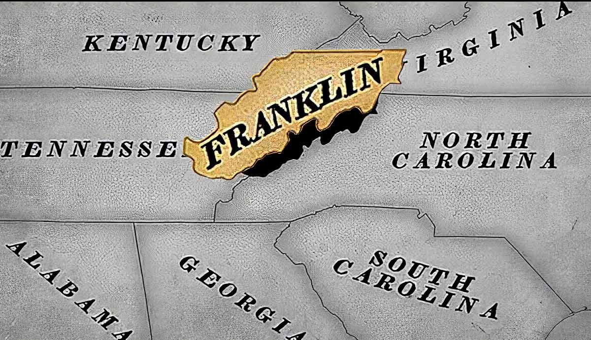
In 1784, the United States was a new country, being governed not by the Constitution but by the Articles of Confederation. This document outlined the 13 states as independent areas that worked with the federal government rather than under it. However, American settlers lived outside of the 13 states as well and wanted to organize formally. Between the Mississippi River and the Appalachian Mountains, these remote settlements sought self-government from federal land grants. One such settlement was the state of Franklin, which existed for almost five years in what is today Eastern Tennessee.
North Carolina & The Land Grab Acts

By the end of the Revolutionary War, the lands of North Carolina extended west into the Cumberland River Valley. These were called simply “the Western Counties” and were originally the lands of the Cherokee, who were still coming to terms with the formation of a new country encroaching upon their ancestral territory.
In late 1783 and early 1784, the state of North Carolina was wary of carrying the responsibility of the remote counties and, therefore, proposed a “Land Grab Act” wherein all of the state’s western lands would be for sale. The land sales were shaky at best, and most of them went to those in the North Carolina Legislature or those who had close business relationships with the government.
In reaction to these questionable sales, in 1784, a newly re-elected state legislature instead proposed another tactic for letting the lands go. The United States had incurred significant debt in the war for American independence. To both rid themselves of caring for the land and to help offset war debt, the government of North Carolina ceded 29,000,000 acres to the federal government, which comprised all the land in North Carolina from the Allegheny (Appalachian) Mountains to the Mississippi River.

The stipulation in this concession, however, was that the federal government would have to assume responsibility for the land in two years. The US government was also wary of this responsibility, knowing that it meant dealing with land leased from the Cherokee Nation, who were still none too pleased about the states’ dealings within their lands.
Thus, North Carolina made yet another change in its holdings; after another new legislature was formed, those who had voted for the Land Grab Acts came back into power and repealed the cession. However, the remote areas that had been tossed around several times were not aware of this change. Encouraged by the federal control of the lands, some 5,000 settlers within the eastern counties of present-day Tennessee had already begun plans to form an independent state.
Formation of the State of Franklin

The heavily populated Greene, Sullivan, and Washington Counties of Western North Carolina were among the only statehood movements that coalesced into formal action. They were both encouraged by the cession of lands to the federal government and by the tradition of self-government.
These counties knew no difference, as their remote location at the time meant that they received hardly any direction or reprimand from the capital of North Carolina. At that time, the legislature was meeting in several locations, including New Bern and Fayetteville, both of which were located much further east than was realistically reachable for the settlers west of the Appalachian Mountains.
In August 1784, in response to North Carolina’s cession to the federal government and unaware of its quick repeal, the independent state of Franklin was formed. There were no fixed boundaries for the state, but there was a possibility of expansion beyond the three most populated counties that first sought independence.

Following its formation, the government of Franklin drafted a declaration of independence, which laid out its complaints against the government of North Carolina. Among other grievances was the issue of distance between the area that comprised the state of Franklin and the North Carolinian legislature, which focused their activity mostly in and around the Eastern Seaboard. Aside from being essentially cut off from their state’s government, this distance also made assistance in the event of a Native American attack unlikely, leaving the comparatively small bunch of settlers to fend for themselves.
Additionally, Franklin’s delegation argued that North Carolina held the western counties in contempt and, for the most part, saw them as a problem. The state of Franklin felt assured in its reasoning for secession and thus moved forward with their plan of self-government.
The state of Franklin’s formation also decreased the popularity of the continuing cession of North Carolina land to the federal government. Eventually, they would regain their land, but those who had formed the Land Grab Acts were unable to reclaim any territory that was technically under Franklin’s control.
Government of the State of Franklin

The proposed state of Franklin met in late 1784 for a constitutional convention and drew out a form of self-government that was, at the time, radical for the young United States. Delegates of the convention put forth a document called the Houston Constitution, which outlined a unicameral legislature, a slew of protections for the freedom of religion, and the requirement that legislation be routinely submitted to the citizens of Franklin for discussion.
Moral strictures were placed on those who could vote, which was limited only to white men. However, property holding was not required for voting rights, which was a novel concept at the time. Additionally, Franklin’s constitution forbade lawyers, doctors, and clergymen from running for public office.

Though the proposed constitution was quite progressive for its time, it failed in referendum, and the state of Franklin operated under a near copy of the North Carolina constitution. Leaders were appointed to several offices, while the most famous was John Sevier, a war hero of the American Revolutionary War-turned governor of the new state. During the appointments of office, a delegate was also sent to the United States Congress to attempt to admit Franklin as the 14th state in the Union. Meanwhile, five new counties were annexed in Franklin.
In June 1785, only a few months after being appointed governor, Sevier met with the Cherokee in the area to discuss land holdings. The Treaty of Dumplin Creek was later contested by the Cherokee and the federal government, who claimed there was never an agreement to settle the land with Franklinites.

The new state’s government interpreted the meaning differently, as many new settlers moved into the area between the French Broad and Little Tennessee Rivers. Though the settlers came, their claim on the land was only justified legally by the state of Franklin, which held little legitimacy in the eyes of the US government.
Eventually, the Cherokee and federal government disregarded the Dumplin Creek treaty. It came to its agreement in Hopewell in November 1785, where both parties agreed that Franklin’s proposed capital of Greeneville sat well inside the boundary of the Cherokee Nation. This reversal, compounded with the rejection of Franklin’s bid for statehood in Congress, began the downhill slide of the newly proposed state.
The economy of Franklin was based on bartering, with even the governor being paid in deer skins. Many citizens settled debts and paid dues with tobacco, alcohol, corn, or animal hides. Despite the barter economy, foreign and federal currencies were also accepted. Citizens were granted a two-year reprieve on taxes, but the reliance on goods as currency and lack of infrastructure made economic decline inevitable.
While county courts were established, there was often infighting among citizens. In addition to internal problems, the government of Franklin often clashed with its neighbors in North Carolina and the Cherokee Nation. It was only a matter of time before a faction of Franklinites began advocating for the rejoining of North Carolina.
The End of Franklin & Its Legacy

The faction of citizens who favored North Carolinian sovereignty was led by a man named John Tipton. In response to followers of Tipton gathering and having their demands increasing in popularity, the governor of Franklin sent an army to Tipton’s home in early 1788. The clash, though brief and not won by either side, was then memorialized as the Battle of the State of Franklin.
The battle was something of a death omen for the state of Franklin, which quickly devolved starting in 1788. Sevier attempted to convince the Spanish to annex his state, which failed, and he was subsequently tried for federal treason. Though Sevier was rescued by his supporters and lived in what the remaining Franklinites called “Lesser Franklin” for some time, eventually, all efforts to make Franklin a state of its own failed by 1789.
In February 1789, Sevier and all other Franklin leaders swore allegiance to North Carolina. The federal government acted quickly and took hold of the original land grants given to them from the North Carolina government, allowing no time for settlers to move in and claim statehood again. Eventually, the state of Franklin was incorporated into the 16th state in the Union, Tennessee, in 1796. Sevier, who had since been involved with the North Carolina state government, became Tennessee’s first governor.

Though the state of Franklin was short-lived, its legacy remains, whether for better or worse, within the United States Constitution. After the failure of the Articles of Confederation, a clause in the new Constitution was added, which stipulated that territory within another state may not be admitted to the union unless both the state legislature and Congress approved of the secession.
The state of Franklin may have ultimately been a failure, but it remains an interesting example of the fluidity with which the young United States operated. It was a time when the new nation was trying to find its footing and its style of government, which came many times through trial and error. The state of Franklin was one such trial that lent to the structure of the eventual Constitution and helped frame what the founding fathers wanted the country to be.


